

The opening of the year 1825 saw Illinois a State of less than a hundred
thousand inhabitants, and the whole of its northern half still a wilderness,
without an organized county, a post-road, or a considerable settlement.
Chicago was little more than "a village in Pike County, situated on Lake
Michigan, at the mouth of Chicago creek, containing twelve or fifteen
houses, and about sixty or seventy inhabitants."*— Peoria was "a small
settlement in Pike Countv, situated on the west bank of the Illinois river,
about 200 miles above its junction with the Mississippi."** A few miners had
clustered about the lead mines in the vicinity of Galena, which had been
opened in 1823; but a road through the unbroken wilderness
*Beck's Gazetteer of Illinois and Missouri. p. 199.
**Ibid, 143.
eastward or southward was not made until late this year, when "Kellogg's
Trail" pointed the devious way from Peoria to Galena.* Not a white man's
habitation, nor a ferry, was to be seen along its entire route. Northern
Illinois was still the roving-ground of the Winnebago and the Pottawatamie.
The "Military Bounty Land Tract" was the first to be settled when the tide
of American emigration began to flow with some rapidity to Illinois; and at
a very early day pioneers had located at various points on its broad
prairies.** This Tract was surveyed by order of the Government in 1815 and
1816, and the greater part subsequently appropriated in bounties to the
soldiers of the regular army in service during the last war with Great
Britain. It was located between the Illinois and Mississippi rivers, and
extended due north 169 miles from the mouth of the Illinois river, to a line
drawn from the great bend of the stream below Peru to the Mississippi, which
it strikes about fifteen miles above New Boston being ninety miles between
the two points. The whole comprises 207 full and 61 fractional
townships—altogether 5,360,000 acres, of which about 3,500,000 were
appropriated for soldiers' bounties. After satisfying the military claims,
the remainder was made subject to entry and purchase, like other Congress
lands; and it was rapidly disposed of.
*History of Ogle County, p. 30.
**Reynolds' Own Times.
The necessity of a county organization on the Military Tract, for judicial
and other purposes, was early apparent. In 1821, Pike county was laid off by
the Legislature, including all that part of the State north and west of the
Illinois river from its junction with the Mississippi to the Kankakee, and
north of the latter to the Indiana line, covering a vast extent of
territory. It was described in 1823 as containing between 700 and 800
inhabitants.* It sent one member to the House of Representatives, and, with
Greene county, one member to the Senate. The county seat at first was Atlas,
and afterwards Colesgrove, mentioned two years after the county was created
as "very little improved," but "bids fair to be a place of some
importance."**
Ten counties were organized within three years after the State government
was formed; but only three were created within the next two years, showing
that emigration had received a check, or that the previous grants of the
Legislature were nearly equal to the demand for new counties. A considerable
number were set off at the session of 1824-5. During the years since the
State organization, the Military Tract had increased its population more,
perhaps, than any other Secof the State;*** and land could be procured
there cheaper than Congress price. It was now thought advisable to divide it
into counties.
*Beck's Gazetteer. §2.
**Ibid, 101.
***Reynolds' Own Times, 238.
On the 6th of December, 1824, in the House of Representatives, Nicholas
Hansen, the member for Pike county, presented a petition for its division
into sundry counties. It was referred to a select committee, of which Hansen
was Chairman, who reported "an act forming a new county out of Pike and the
attached portion thereof." On the second reading, it was referred back, with
directions to inquire if it would not be expedient to lay off the whole
Military Tract into counties, and if so, to report by bill. A new Committee
was soon after appointed, with definite instructions to divide the Military
Tract into counties, under such regulations as they should deem expedient.
Accordingly they reported "An act forming a new county in the vicinity of
Fort Clark," (Peoria county,) and "An act forming new counties out of the
counties of Fulton* and Pike, and the attached portions thereof." The bills
passed their several readings without difficulty; and on the 30th December
were carried through the House. In Senate shortly after, both were passed
and sent back with amendments. The House concurred in an amendment to the
first bill, but refused to concur in the amendments to the second.
Subsequently, however, its action was re-considered, the amendments passed,
and the bill became a law Jan. 13th, 1825.**
*Fulton had just been created at the same session.
**See House Journal for 1824-5.
This act provided for the formation of Schuyler, Adams, Hancock, Warren,
Mercer, Henry, Knox, and Putnam counties.* The provisions for the erection
of each were substantially the same. Putnam county occupies but a single
section:
Sec. 7. Be it further enacted, That all that tract of country within the
following boundaries, to wit: Beginning at the point where the township line
between Townships 11 and 12 north touches the Illinois river, thence up the
said river to the south fork thereof, thence up the said fork to the line
dividing this State from Indiana, thence up the said line to the north-east
corner of this State, thence west on the north boundary line thereof to the
range line between ranges 4 and 5 east, and thence south on said range line
to the line between Townships 11 and 12 north, thence east to the place of
beginning, shall constitute a County, to be called the County of Putnam.**
These boundaries, stretching from the present northern limit of Peoria
county along the Illinois and Kankakee rivers, the Indiana line, lake shore,
and Wisconsin boundary to a point only 35 miles from the Mississippi, and
thence due southward 105 miles, included nearly 11,000 square miles, being
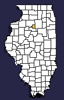
the tract now covered by Bureau, Stark, Kendall, Lee, Ogle, DeKalb, Kane,
Boone, Lake, DuPage, McHenry, Stephenson, Winnebago, and Cook counties, and
portions of later Putnam, Marshall, Henry, La Salle,
*It will be observed that all these counties are named from Revolutionary
heroes.
**Revised Laws 1824-5, p. 94.
Grundy, Will, Kankakee, Carroll, Whiteside, and Jo Daviess. Chicago was the
only town in this great wilderness county.
As soon as the county had 350 inhabitants, they were authorized to organize
and elect county officers, for which the Judge of the Circuit Court was
directed to issue an order. In 1830, Putnam and Peoria counties (whose
census returns were united) contained 1,310 whites;* and Putnam has been
estimated to have had at that time a population of about 700.** It was never
organized, however, as its people were too widely scattered to make
organization convenient or necessary. Whatever judicial business there was
appears to have been transacted at Peoria. The county was ignored by
subsequent Legislatures, in the formation of other counties upon its
territory; and it was not recognized even in the act of 1831, creating the
present county of that name. Nevertheless, it has usually been considered by
writers on Illinois as the original of the present Putnam, and is so
mentioned in their works.***
*U. S. Census Rep. 1830, 149.
**Peoria Register, June 30, '38.
***See Peck's New Guide for Emigrants, Peck's Gazetteer of Illinois (both
editions), Ellsworth's Illinois in 1837, etc., etc.
Source: Extracted from History of Putnam & Marshall Counties; Embracing an
Account of the Settlement, Early Progress, and Formation of Bureau and Stark
Counties; With an Appendix, Containing Notices of Old Settlers and of the
Antiquities of Putnam and Marshall, Lists of Officers of Each County from
its Organization to the Present Time, etc., etc.; By Henry A. Ford,
Corresponding Member of the Chicago Historical Society; Lacon, ILL.:
Published for the Author; 1860.
Source: History of Putnam and Marshall Counties authored by Henry Allen Ford, published in 1860
| Bureau |  |
LaSalle |
| Marshall |